
http://wiki.x-plane.com/Category:X-Plane_for_iPad_manual
X-Plane for iPad manual
第5章:地域フライトについて
X-Plane for iPad/X-Plane HDEF 4G includes more than twenty flight regions, ranging from the deserts of California to the snowy mountains of Nepal. Let's look at these regions in depth.
X線平面は、アプリ/ X線平面HDEF4Gのためのカリフォルニアの砂漠からネパールの雪山に至るまで、20以上の飛行領域を含む。の深さが、これらの地域を見てみましょう。
Contents
Innsbruck, Austria(インスブルック、オーストリア)
The Innsbruck region has some of the most highly detailed scenery found in X-Plane for iPad/X-Plane HDEF 4G. Note the accurately reproduced airport terminal buildings and the super-high-definition textures, as seen below.
インスブルック領域は、アプリ/ X線平面HDEF4GのためのX線平面に見られる最も高精細な風景のいくつかを持っています。以下に見られるように、正確に再現空港ターミナルビルや超高精細テクスチャを注意してください。
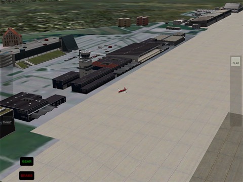
The Innsbruck airport terminal
Innsbruck includes Innsbruck Airport (LOWI).
インスブルック空港ターミナル
インスブルックはインスブルック空港(LOWI)が含まれています。
Hawaii(ハワイ)
The Hawaii region includes nearly the whole of the Maui and Lanai islands. Its main airports are Kahului Airport (PHOG) and Lanai Airport (PHNY). With the close combination of flats, gently sloping mountains, jagged peaks, and the ocean, Hawaii makes a beautiful place to fly.
This region has an aircraft carrier situated in the south for use with carrier-capable fighters.
ハワイ領域は、マウイ島とラナイ島のほぼ全体が含まれています。その主な空港カフルイ空港( PHOG )とラナイ空港( PHNY )です。アパート、なだらかな山々 、ギザギザのピークと海の近くに組み合わせて、ハワイは飛行する美しい場所です。
この領域は、キャリア対応の戦闘機で使用するための南に位置して空母を持っています。
Miami, Florida(マイアミ、フロリダ州)
The Miami region spans from Tavernier in the south, to North Miami Beach in the northeast, to Marco Island in the northwest. It encompasses all of Everglades National Park, and includes an aircraft carrier in the west.
マイアミの領域は北西にあるマルコ島に北東、北マイアミビーチに、南はタヴェルニエから及ぶ。それは、エバーグレーズ国立公園のすべてを包含し、西の空母が含まれています。
Southern California(南カリフォルニア)
The Southern California region spans the coast of California from Imperial Beach in the south to Barstow in the northeast to Edwards Air Force Base in the northwest. It includes San Bernardino International (KSBD), San Diego International (KSAN), and Ontario International (KONT) airports, as well as an aircraft carrier (located near the center of the map).
南カリフォルニア地域は北西にあるエドワーズ空軍基地への北東にバーストーに南のインペリアルビーチからカリフォルニアの海岸にまたがる。これは、サンバーナーディーノ国際( KSBD ) 、サンディエゴ国際(クサンインディアン村) 、およびオンタリオ国際( KONT )空港だけでなく、 (マップの中央付近に位置する)空母が含まれています。
Santa Catalina Island, California(サンタカタリナ島、カリフォルニア州)
Santa Catalina Island forms the center of this map, with Long Beach and Los Angeles in the north. Prominent airports include Catalina Airport (KAVX) and Los Angeles International Airport, as well as an aircraft carrier located just north of Catalina Island.
サンタ·カタリナ島は、北のロングビーチ、ロサンゼルスでは、この地図の中心を形成している。著名な空港カタリナ空港( KAVX )とロサンゼルス国際空港だけでなく、すぐ北カタリナ島の位置空母が含まれています。
Van Nuys, California(ヴァンナイス、カリフォルニア州)
The Van Nuys region extends from Mojave in the northeast to Thousand Oaks in the southwest. Prominent airports include Van Nuys Airport (KVNY) and Bob Hope Airport (KBUR) in Burbank.
バンナイズ領域は、南西部のサウザンドオークスに北東部のモハーベから延びている。著名な空港バンナイズ空港( KVNY )とバーバンクのボブ·ホープ空港( KBUR )が含まれています。
San Francisco, California(サンフランシスコ、カリフォルニア州)
The San Francisco region spans from San Rafael in the northwest, to Concord in the northeast, to Santa Cruz in the south. Note the very high level of detail at San Francisco International Airport (KSFO)—runway lights, terminal buildings, and the network of taxiways are all accurately modeled, as seen below.
サンフランシスコ地域は南部のサンタクルスに北東にコンコードに、北西部のサンラファエルから及ぶ。サンフランシスコ国際空港( KSFO )での細部の非常に高いレベルの下に見られるよう、滑走路灯、ターミナルビル、および誘導路のネットワークがすべて正確にモデル化されていることに注意してください。
The KSFO airport terminal
Additionally, there is an aircraft carrier located off the west coast near the center of the map.
KSFOの空港ターミナル
また、マップの中心に近い西海岸すぐそば空母があります。
Big Bear, California(ビッグベアー、カリフォルニア州)
The Big Bear region extends from Big Bear City Airport (L35) in the south up to Barstow, California in the north, and includes Twentynine Palms Airport (KNXP).
ビッグベアー領域は、北はバーストー、カリフォルニア州の南までにビッグベアシティ空港(L35)から延びており、トゥウェンティナイン空港(KNXP)が含まれています。
Grand Canyon(グランドキャニオン)
The Grand Canyon map covers hundreds of square miles of Grand Canyon National Park in Arizona. It includes four fictional airports from which to explore the spectacular canyons of the area. The OZ_V mini-heliport (seen from a distance in the image below) even starts users out from within the canyon!
グランドキャニオンマップは、アリゾナ州のグランドキャニオン国立公園の平方数百マイルをカバーしています。それは、地域の壮大な峡谷を探索する、そこから4架空の空港が含まれています。 (下の画像の距離から見て)OZ_Vミニヘリポートも、峡谷内からユーザーを開始します!
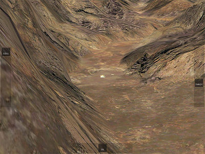
Starting within the Grand Canyon
グランドキャニオン内の開始
Provost, Utah(学長、ユタ州)
The Provost region is bordered by Salt Lake City International Airport in the northwest, with the Strawberry Reservoir and Uinta National Forest in its southeastern corner.
学長領域は、その南東の隅にストロベリー貯水池とユインタ国有林で、北西にソルトレイクシティ国際空港に隣接しています。
Canyons(キャニオンズ)
The fictitious Canyons region is filled with five airports and lots and lots of canyons. You're virtually guaranteed to have some mountain peaks in view any time you tap the Random Location button in the Map screen.
架空キャニオンズ領域は5空港や場や峡谷の多くで満たされている。あなたは、実質ビューで、地図画面にランダムな位置のボタンをタップするたびに、いくつかの山のピークを持つことが保証している。
Southern California Desert(南カリフォルニアの砂漠)
The Southern California Desert region spans about 60 miles from Palm Springs in the northeast to Ramona in the southwest and includes Palm Springs International Airport (KPSP).
南カリフォルニアの砂漠地域は南西ラモナに北東に約60マイルパームスプリングスからまたがり、パームスプリングス国際空港( KPSP )が含まれています。
Desert Sky, California(砂漠空、カリフォルニア州)
The Desert Sky region encompasses much of the Salton Sea, and it is virtually right next door to the Southern California Desert map.
砂漠の空領域は、ソルトン湖の大部分を包含しており、南カリフォルニアの砂漠マップの隣に事実上権利である。
New York(ニューヨーク)
The New York region contains nearly all of New York City in the northeast and reaches down past Trenton, New Jersey in the southwest. Prominent airports include La Guardia Airport, John F. Kennedy International Airport, and Trenton Mercer Airport (KTTN), though there are over a hundred total airports in the region.
New York also features an aircraft carrier near the center of the map.
ニューヨーク領域は、ほぼすべての北東部ニューヨークのが含まれており、南西にトレントン、ニュージャージー州を過ぎてダウン達する。著名な空港地域の百合計空港経由でありますが、ラガーディア空港、ジョン·F·ケネディ国際空港、トレントン·マーサー空港( KTTN )が含まれています。
ニューヨークには、地図の中心付近の空母を提供しています。
Chicago, Illinois(シカゴ、イリノイ州)
The Chicago region reaches from Kankakee, Illinois in the south to Milwaukee, Wisconsin in the north along the Lake Michigan shore. Prominent airports include Kenosha Regional Airport (KENW), Chicago Executive Airport (KPWK), Chicago O'Hare International Airport (KORD), and Chicago Midway International Airport (KMDW).
シカゴ領域はミルウォーキー、ミシガン湖の岸に沿って北のウィスコンシン州にカンカキー、南部のイリノイ州から届く。著名な空港キノー地方空港( KENW ) 、シカゴエグゼクティブ空港( KPWK ) 、シカゴ·オヘア国際空港( KORD ) 、シカゴミッドウェイ国際空港( KMDW )が含まれています。
Seattle-Tacoma area, Washington(シアトル·タコマエリア、ワシントン)
The Seattle-Tacoma region stretches from Everett, Washington in the northeast down to Olympia, Washington in the southwest. It contains Seattle-Tacoma International Airport (KSEA), Bremerton National Airport (KPWT), and McChord Air Force Base (KTCM).
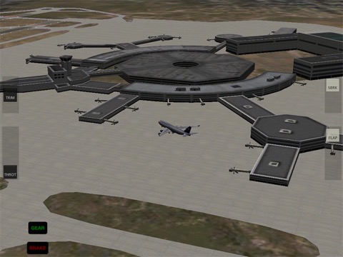
Note especially the detail in the Seattle-Tacoma Int'l terminal, as seen in the following image:
シアトル·タコマ地域は南西部オリンピア、ワシントン北東ダウンにエベレット、ワシントン州から広がっています。それはシアトル·タコマ国際空港( KSEA ) 、ブレマートンナショナル空港( KPWT ) 、およびマコード空軍基地( KTCM )が含まれています。
次の図に見られるように、シアトル·タコマ国際ターミナルで、特に詳細に注意してください。

The KSEA terminal
KSEA端子
Juneau, Alaska(ジュノー、アラスカ州)
The Juneau region centers on Juneau International Airport (PAJN). With lots of frigid water and snowy mountains, it makes for a beautiful flight.
ジュノー領域はジュノー国際空港( PAJN )を中心とした。極寒の水と雪に覆われた山々の多くと、それは美しいフライトのためになります。
Kathmandu, Nepal(カトマンズ、ネパール)
The Kathmandu region centers around Tribhuvan International Airport (VNKT), located in the mountains of Nepal.
カトマンズ領域は、ネパールの山中にトリブバン国際空港( VNKT )を中心に中央に配置されます。
Boswell Bay, Alaska(ボズウェル湾、アラスカ州)
The Boswell Bay region features prominently Boswell Bay and a large portion of Prince William Sound, located in southeastern Alaska. It also includes an aircraft carrier near the center of the map.
ボズウェル湾地域は、目立つようにボズウェル湾と南東アラスカに位置プリンス·ウィリアム湾の大部分を提供しています。また、地図の中心付近の空母が含まれています。
Anchorage, Alaska(アンカレッジ、アラスカ州)
Anchorage lies about a hundred miles to the west of Boswell Bay. The map features Ted Stevens Anchorage International Airport (PANC), as well as an aircraft carrier.
アンカレッジはボズウェル湾の西へ百マイル程度ある。マップは、テッド·スティーブンス·アンカレッジ国際空港( PANC )だけでなく、空母を備えています。
Edwards Air Force Base, California(エドワーズ空軍基地、カリフォルニア州)
The Edwards AFB region spans from Sequoia National Forest in the northwest all the way down to San Bernardino in the southeast. It includes Van Nuys Airport (KVNY) in the southwest, as well as Ontario International Airport (KONT) and, of course, Edwards Air Force Base (KEDW).
エドワーズAFB領域は、全押し南東部のサンバーナーディーノの北西にセコイア国有林から及ぶ。それは、当然のことながら、エドワーズ空軍基地( KEDW )の南西にあるバンナイズ空港( KVNY )だけでなく、オンタリオ国際空港( KONT )が含まれます。
Cocoa Beach, Florida(ココアビーチ、フロリダ州)
The Cocoa Beach region (and specifically the Kennedy Space Center in Cape Canaveral), is the site of the Space Shuttle launch. The region's default airport is Space Coast Regional (KTIX), the nearest commercial airport to the Kennedy Space Center. The most prominent airport, the NASA Shuttle Landing Facility (KTTS), lies to the northeast of it. Additionally, a carrier is included off the west coast of Cape Canaveral.
ココアビーチ地域(ケープカナベラル、具体的にはケネディ宇宙センター)は、スペースシャトルの打ち上げのサイトです。地域のデフォルトの空港は、スペースコースト地域(KTIX)、ケネディ宇宙センターに最も近い商業空港です。最も顕著な空港は、米航空宇宙局(NASA)のシャトル着陸施設(KTTS)は、それの北東に位置しています。さらに、キャリアはケープカナベラルの西海岸をオフに含まれています。
第5章:地域フライトについて
X-Plane for iPad/X-Plane HDEF 4G includes more than twenty flight regions, ranging from the deserts of California to the snowy mountains of Nepal. Let's look at these regions in depth.
X線平面は、アプリ/ X線平面HDEF4Gのためのカリフォルニアの砂漠からネパールの雪山に至るまで、20以上の飛行領域を含む。の深さが、これらの地域を見てみましょう。
Contents
- Innsbruck, Austria
- Hawaii
- Miami, Florida
- Southern California
- Santa Catalina Island, California
- Van Nuys, California
- San Francisco, California
- Big Bear, California
- Grand Canyon
- Provost, Utah
- Canyons
- Southern California Desert
- Desert Sky, California
- New York
- Chicago, Illinois
- Seattle-Tacoma area, Washington
- Juneau, Alaska
- Kathmandu, Nepal
- Boswell Bay, Alaska
- Anchorage, Alaska
- Edwards Air Force Base, California
- Cocoa Beach, Florida
Innsbruck, Austria(インスブルック、オーストリア)
The Innsbruck region has some of the most highly detailed scenery found in X-Plane for iPad/X-Plane HDEF 4G. Note the accurately reproduced airport terminal buildings and the super-high-definition textures, as seen below.
インスブルック領域は、アプリ/ X線平面HDEF4GのためのX線平面に見られる最も高精細な風景のいくつかを持っています。以下に見られるように、正確に再現空港ターミナルビルや超高精細テクスチャを注意してください。
The Innsbruck airport terminal
Innsbruck includes Innsbruck Airport (LOWI).
インスブルック空港ターミナル
インスブルックはインスブルック空港(LOWI)が含まれています。
Hawaii(ハワイ)
The Hawaii region includes nearly the whole of the Maui and Lanai islands. Its main airports are Kahului Airport (PHOG) and Lanai Airport (PHNY). With the close combination of flats, gently sloping mountains, jagged peaks, and the ocean, Hawaii makes a beautiful place to fly.
This region has an aircraft carrier situated in the south for use with carrier-capable fighters.
ハワイ領域は、マウイ島とラナイ島のほぼ全体が含まれています。その主な空港カフルイ空港( PHOG )とラナイ空港( PHNY )です。アパート、なだらかな山々 、ギザギザのピークと海の近くに組み合わせて、ハワイは飛行する美しい場所です。
この領域は、キャリア対応の戦闘機で使用するための南に位置して空母を持っています。
Miami, Florida(マイアミ、フロリダ州)
The Miami region spans from Tavernier in the south, to North Miami Beach in the northeast, to Marco Island in the northwest. It encompasses all of Everglades National Park, and includes an aircraft carrier in the west.
マイアミの領域は北西にあるマルコ島に北東、北マイアミビーチに、南はタヴェルニエから及ぶ。それは、エバーグレーズ国立公園のすべてを包含し、西の空母が含まれています。
Southern California(南カリフォルニア)
The Southern California region spans the coast of California from Imperial Beach in the south to Barstow in the northeast to Edwards Air Force Base in the northwest. It includes San Bernardino International (KSBD), San Diego International (KSAN), and Ontario International (KONT) airports, as well as an aircraft carrier (located near the center of the map).
南カリフォルニア地域は北西にあるエドワーズ空軍基地への北東にバーストーに南のインペリアルビーチからカリフォルニアの海岸にまたがる。これは、サンバーナーディーノ国際( KSBD ) 、サンディエゴ国際(クサンインディアン村) 、およびオンタリオ国際( KONT )空港だけでなく、 (マップの中央付近に位置する)空母が含まれています。
Santa Catalina Island, California(サンタカタリナ島、カリフォルニア州)
Santa Catalina Island forms the center of this map, with Long Beach and Los Angeles in the north. Prominent airports include Catalina Airport (KAVX) and Los Angeles International Airport, as well as an aircraft carrier located just north of Catalina Island.
サンタ·カタリナ島は、北のロングビーチ、ロサンゼルスでは、この地図の中心を形成している。著名な空港カタリナ空港( KAVX )とロサンゼルス国際空港だけでなく、すぐ北カタリナ島の位置空母が含まれています。
Van Nuys, California(ヴァンナイス、カリフォルニア州)
The Van Nuys region extends from Mojave in the northeast to Thousand Oaks in the southwest. Prominent airports include Van Nuys Airport (KVNY) and Bob Hope Airport (KBUR) in Burbank.
バンナイズ領域は、南西部のサウザンドオークスに北東部のモハーベから延びている。著名な空港バンナイズ空港( KVNY )とバーバンクのボブ·ホープ空港( KBUR )が含まれています。
San Francisco, California(サンフランシスコ、カリフォルニア州)
The San Francisco region spans from San Rafael in the northwest, to Concord in the northeast, to Santa Cruz in the south. Note the very high level of detail at San Francisco International Airport (KSFO)—runway lights, terminal buildings, and the network of taxiways are all accurately modeled, as seen below.
サンフランシスコ地域は南部のサンタクルスに北東にコンコードに、北西部のサンラファエルから及ぶ。サンフランシスコ国際空港( KSFO )での細部の非常に高いレベルの下に見られるよう、滑走路灯、ターミナルビル、および誘導路のネットワークがすべて正確にモデル化されていることに注意してください。
The KSFO airport terminal
Additionally, there is an aircraft carrier located off the west coast near the center of the map.
KSFOの空港ターミナル
また、マップの中心に近い西海岸すぐそば空母があります。
Big Bear, California(ビッグベアー、カリフォルニア州)
The Big Bear region extends from Big Bear City Airport (L35) in the south up to Barstow, California in the north, and includes Twentynine Palms Airport (KNXP).
ビッグベアー領域は、北はバーストー、カリフォルニア州の南までにビッグベアシティ空港(L35)から延びており、トゥウェンティナイン空港(KNXP)が含まれています。
Grand Canyon(グランドキャニオン)
The Grand Canyon map covers hundreds of square miles of Grand Canyon National Park in Arizona. It includes four fictional airports from which to explore the spectacular canyons of the area. The OZ_V mini-heliport (seen from a distance in the image below) even starts users out from within the canyon!
グランドキャニオンマップは、アリゾナ州のグランドキャニオン国立公園の平方数百マイルをカバーしています。それは、地域の壮大な峡谷を探索する、そこから4架空の空港が含まれています。 (下の画像の距離から見て)OZ_Vミニヘリポートも、峡谷内からユーザーを開始します!
Starting within the Grand Canyon
グランドキャニオン内の開始
Provost, Utah(学長、ユタ州)
The Provost region is bordered by Salt Lake City International Airport in the northwest, with the Strawberry Reservoir and Uinta National Forest in its southeastern corner.
学長領域は、その南東の隅にストロベリー貯水池とユインタ国有林で、北西にソルトレイクシティ国際空港に隣接しています。
Canyons(キャニオンズ)
The fictitious Canyons region is filled with five airports and lots and lots of canyons. You're virtually guaranteed to have some mountain peaks in view any time you tap the Random Location button in the Map screen.
架空キャニオンズ領域は5空港や場や峡谷の多くで満たされている。あなたは、実質ビューで、地図画面にランダムな位置のボタンをタップするたびに、いくつかの山のピークを持つことが保証している。
Southern California Desert(南カリフォルニアの砂漠)
The Southern California Desert region spans about 60 miles from Palm Springs in the northeast to Ramona in the southwest and includes Palm Springs International Airport (KPSP).
南カリフォルニアの砂漠地域は南西ラモナに北東に約60マイルパームスプリングスからまたがり、パームスプリングス国際空港( KPSP )が含まれています。
Desert Sky, California(砂漠空、カリフォルニア州)
The Desert Sky region encompasses much of the Salton Sea, and it is virtually right next door to the Southern California Desert map.
砂漠の空領域は、ソルトン湖の大部分を包含しており、南カリフォルニアの砂漠マップの隣に事実上権利である。
New York(ニューヨーク)
The New York region contains nearly all of New York City in the northeast and reaches down past Trenton, New Jersey in the southwest. Prominent airports include La Guardia Airport, John F. Kennedy International Airport, and Trenton Mercer Airport (KTTN), though there are over a hundred total airports in the region.
New York also features an aircraft carrier near the center of the map.
ニューヨーク領域は、ほぼすべての北東部ニューヨークのが含まれており、南西にトレントン、ニュージャージー州を過ぎてダウン達する。著名な空港地域の百合計空港経由でありますが、ラガーディア空港、ジョン·F·ケネディ国際空港、トレントン·マーサー空港( KTTN )が含まれています。
ニューヨークには、地図の中心付近の空母を提供しています。
Chicago, Illinois(シカゴ、イリノイ州)
The Chicago region reaches from Kankakee, Illinois in the south to Milwaukee, Wisconsin in the north along the Lake Michigan shore. Prominent airports include Kenosha Regional Airport (KENW), Chicago Executive Airport (KPWK), Chicago O'Hare International Airport (KORD), and Chicago Midway International Airport (KMDW).
シカゴ領域はミルウォーキー、ミシガン湖の岸に沿って北のウィスコンシン州にカンカキー、南部のイリノイ州から届く。著名な空港キノー地方空港( KENW ) 、シカゴエグゼクティブ空港( KPWK ) 、シカゴ·オヘア国際空港( KORD ) 、シカゴミッドウェイ国際空港( KMDW )が含まれています。
Seattle-Tacoma area, Washington(シアトル·タコマエリア、ワシントン)
The Seattle-Tacoma region stretches from Everett, Washington in the northeast down to Olympia, Washington in the southwest. It contains Seattle-Tacoma International Airport (KSEA), Bremerton National Airport (KPWT), and McChord Air Force Base (KTCM).
Note especially the detail in the Seattle-Tacoma Int'l terminal, as seen in the following image:
シアトル·タコマ地域は南西部オリンピア、ワシントン北東ダウンにエベレット、ワシントン州から広がっています。それはシアトル·タコマ国際空港( KSEA ) 、ブレマートンナショナル空港( KPWT ) 、およびマコード空軍基地( KTCM )が含まれています。
次の図に見られるように、シアトル·タコマ国際ターミナルで、特に詳細に注意してください。
The KSEA terminal
KSEA端子
Juneau, Alaska(ジュノー、アラスカ州)
The Juneau region centers on Juneau International Airport (PAJN). With lots of frigid water and snowy mountains, it makes for a beautiful flight.
ジュノー領域はジュノー国際空港( PAJN )を中心とした。極寒の水と雪に覆われた山々の多くと、それは美しいフライトのためになります。
Kathmandu, Nepal(カトマンズ、ネパール)
The Kathmandu region centers around Tribhuvan International Airport (VNKT), located in the mountains of Nepal.
カトマンズ領域は、ネパールの山中にトリブバン国際空港( VNKT )を中心に中央に配置されます。
Boswell Bay, Alaska(ボズウェル湾、アラスカ州)
The Boswell Bay region features prominently Boswell Bay and a large portion of Prince William Sound, located in southeastern Alaska. It also includes an aircraft carrier near the center of the map.
ボズウェル湾地域は、目立つようにボズウェル湾と南東アラスカに位置プリンス·ウィリアム湾の大部分を提供しています。また、地図の中心付近の空母が含まれています。
Anchorage, Alaska(アンカレッジ、アラスカ州)
Anchorage lies about a hundred miles to the west of Boswell Bay. The map features Ted Stevens Anchorage International Airport (PANC), as well as an aircraft carrier.
アンカレッジはボズウェル湾の西へ百マイル程度ある。マップは、テッド·スティーブンス·アンカレッジ国際空港( PANC )だけでなく、空母を備えています。
Edwards Air Force Base, California(エドワーズ空軍基地、カリフォルニア州)
The Edwards AFB region spans from Sequoia National Forest in the northwest all the way down to San Bernardino in the southeast. It includes Van Nuys Airport (KVNY) in the southwest, as well as Ontario International Airport (KONT) and, of course, Edwards Air Force Base (KEDW).
エドワーズAFB領域は、全押し南東部のサンバーナーディーノの北西にセコイア国有林から及ぶ。それは、当然のことながら、エドワーズ空軍基地( KEDW )の南西にあるバンナイズ空港( KVNY )だけでなく、オンタリオ国際空港( KONT )が含まれます。
Cocoa Beach, Florida(ココアビーチ、フロリダ州)
The Cocoa Beach region (and specifically the Kennedy Space Center in Cape Canaveral), is the site of the Space Shuttle launch. The region's default airport is Space Coast Regional (KTIX), the nearest commercial airport to the Kennedy Space Center. The most prominent airport, the NASA Shuttle Landing Facility (KTTS), lies to the northeast of it. Additionally, a carrier is included off the west coast of Cape Canaveral.
ココアビーチ地域(ケープカナベラル、具体的にはケネディ宇宙センター)は、スペースシャトルの打ち上げのサイトです。地域のデフォルトの空港は、スペースコースト地域(KTIX)、ケネディ宇宙センターに最も近い商業空港です。最も顕著な空港は、米航空宇宙局(NASA)のシャトル着陸施設(KTTS)は、それの北東に位置しています。さらに、キャリアはケープカナベラルの西海岸をオフに含まれています。